Sorry.
More importantly, we recently had an amazing trip to the west coast. New Zealand's west coast (of the south island) is super remote. In it's 9,000 square miles, it's home to only about 32,000 people. Less than 4 people per square mile!
Which is exactly what it felt like when we pulled up to our bach near this beach:
 |
| Where is everybody? Wait, I don't care! |
Let me take a moment to explain why the photos in this post (and presumably many future posts) are such low resolution and/or directly pilfered from my Instagram: the camera broke.
Well that didn't even take a moment.
Moving on. The desolate beach, looking back at the baches:

Our whole plan to visit the west coast was relatively last minute, so we only had 2 nights. We shot over after a short day of work Friday, just in time to enjoy the Cape Foulwind seal colony. I assume the cape gets it's name from frequent stormy weather... but let me tell you, when many seals get together and you are downwind... the name may be a double entendre.
We hiked well above the seals and enjoyed the views. And some bread and cheese. And the most horrible beer I've ever had in my life. (It was on sale, and from Russia, so I deserved it.)
Anyways, Cape Foulwind:


Isn't New Zealand's west coast already the most beautiful thing you've ever seen?!
We watched the sun set, and grabbed amazing burgers (and GOOD beer) at the local tavern. The west coast is rugged, and so are it's people. Sure there's fancy places to eat (like one), but when in Rome... order a beer and play pool.
In the morning we drove south, on route to a cave hike, but stopped first at this amazing little beach. Well, stumbled upon really.

I hate photos that do no justice. This is doing no justice.
We walked along the beach to a rocky bluff, lured over by the sight of a small bridge connecting two massive outcroppings, like the entrance to a castle.

Back in the car, we drove south another 40 minutes or so to the Paparoa National Park. Oh, what beautiful mountains... Anyhow, I had read about a hike to Fox Cave in the ever trusty guide book. The page has been folded down for a few years, and there's even highlighter mark presumably from our honeymoon... so it was about time to check it out!
The hike started innocently enough. After about 30 minutes though, we lost the trail. Or rather, the trail went directly into the river, but we followed a small scramble-track for at least 30 minutes straight up the side of a mountain. I can only assume this track is for local hunters or scientists, and it was quite cool, but when we were 110% sure we were on the wrong path (and no longer certain where we even were) we turned back.
This time we took our shoes off and forded the river like good Kiwi hikers on a gentle stroll. (Note to self: go barefoot at all times for tougher soles, riverbeds hurt!)
Back on track, we started ascending again but this time with frequent trail markers. The trail itself started getting quite cool, with big mossy rocks and small waterfalls about.
Once we reached the cave, I really had no idea what we were looking at at all:


We spent 20-30 minutes clambering in the cave before we reached deeper (not too deep, but too cold!) water and decided to turn back. Walking out of the cave felt like walking out of the grocery store on a summer day, let me tell you! The world is a hot, humid place compared to the guts of a cave!

Joyce Bay and Constant bay are "twin bays" near Charlston, NZ. On the map, it looks like the cartographer (map maker) accidentally hit copy-paste on the coast and plunked the same bay down twice. Anyways, we checked them both out. They were both very pretty. And difficult to tell apart.
Part of our original plan had been to go out at dusk on the search for a great spotted kiwi. (Did you know that the great spotted kiwi, the largest of all kiwis, can grow to be 45cm tall and weigh 3.3kg - over 7 pounds! Who knew?!)
As the time came, we sort of realized with the kiwi population being what it is (scarce) and our utter lack of knowledge of where to even look (besides the obvious: mountains, forest), and being that we were currently on the beach thus facing and hour or more drive at dinner time.... we scrapped the plan.
I'd like to note that the plan is not permanently scrapped, and there is a company that will take you out in the wild to a known kiwi breeding area so that you can spot one in the wild (well, 91% of the time, allegedly). So the plan is on hold, with better... planning.
Our revision was to return to Cape Foulwind where we had seen signs for little blue penguin crossing. Penguins are most commonly spotted at dusk or just before, cruising up to their burrows, sometimes several hundred meters from the ocean.
Perfect, we though. Except. It's penguin-molting season. And apparently, when they molt, they never actually leave their burrows.
So, foiled again. But we looked anyways, and enjoyed the sunset and another moment which felt so similar to several others on this trip: like nothing could be more beautiful in the world. At least, at that moment.
.jpg)
.jpg)
I know you were worried... there hasn't been one mention of bikes! No, no, we'd never leave thekids bikes at home! What if they missed us?
On our last morning we revisited Denniston Plateau, a place we went last time we were on the west coast, but were forced to abandon due to poor weather.
This time we had great weather. Unfortunately, the trails are a bit difficult to find. We were on and off several different ones (color coded, "how did we get on red?" "Were we going for blue?" "Why has that sign got a rainbow on it, what does that mean?"). So we spent a fair amount of time wondering if we were missing the good stuff, but we still had good fun.
I took a few photos of Scott on some unexpectedly gnarly sections of trail:
And he took one of me during our brief time on Mars:

After our ride and lunch, time started chasing us. We both had to work early in the morning, but had no desire to leave. It was arguably the nicest day we'd had yet (ok, every single one was perfect) and we felt no rush. We drove in a leisurely way down the coast towards Greymouth, where we would have to turn inland. We stopped several times, and on one stop I snapped this:

Camera phone or not, is this not the most beautiful place you've ever seen?! I know!!!
Now I just need to be philosophical for a moment here.
There are hard things about living abroad. Missing family and friends goes without saying. Missing places, food, certain ways of life. Leaning new cultures, etc. There's challenges, but a lot of it is why you move.
But the hardest thing for me about living in New Zealand is this: the longer I live here, the more I realize that I can never see it all. And this is a place you want to see all of. Or at least I do. I will never tire of the ferns, the rivers, the glaciers. I can't see one too many dramatic mountains, hear too many native birds, or tire of the smell of the beech forest.
Every time we travel, whether it be an hour-long drive to Akaroa, or across the island, we see signs. They're usually yellow, and always point down a dirt road. Waterfall. Gorge. River. Outlook. Scenic Route. (This one always kills me, because every road is the scenic route.) We're always enroute to somewhere, and though we can occasionally stop and explore, we often can't, and we certainly couldn't see them all.
We've been in New Zealand for two years and I've realized this: I'm never going to get enough. I don't know how long we're going to stay here, and I get excited about all kinds of other opportunities around the world. But be it 2 more months or 2 more years, or a lifetime... It would be impossible to see it all. It's something I have to learn to be okay with, as a part of my heart now belongs to New Zealand's little side roads.

This road popped up on our left just a few moments before we needed to turn inland and end our journey. We were chasing sun and pressed for time and it was gated off. But this time we stopped anyways, and walked, and threw rocks in the river, and marveled at the cliffs, and chased dragon flies and enjoyed a moment of unplanned happiness.
And then we happily drove home.
 |
| Ugly, eh? |
Our whole plan to visit the west coast was relatively last minute, so we only had 2 nights. We shot over after a short day of work Friday, just in time to enjoy the Cape Foulwind seal colony. I assume the cape gets it's name from frequent stormy weather... but let me tell you, when many seals get together and you are downwind... the name may be a double entendre.
We hiked well above the seals and enjoyed the views. And some bread and cheese. And the most horrible beer I've ever had in my life. (It was on sale, and from Russia, so I deserved it.)
Anyways, Cape Foulwind:
Isn't New Zealand's west coast already the most beautiful thing you've ever seen?!
We watched the sun set, and grabbed amazing burgers (and GOOD beer) at the local tavern. The west coast is rugged, and so are it's people. Sure there's fancy places to eat (like one), but when in Rome... order a beer and play pool.
In the morning we drove south, on route to a cave hike, but stopped first at this amazing little beach. Well, stumbled upon really.
I hate photos that do no justice. This is doing no justice.
We walked along the beach to a rocky bluff, lured over by the sight of a small bridge connecting two massive outcroppings, like the entrance to a castle.
 |
| Ok, not so castle like... but from afar! |
The hike started innocently enough. After about 30 minutes though, we lost the trail. Or rather, the trail went directly into the river, but we followed a small scramble-track for at least 30 minutes straight up the side of a mountain. I can only assume this track is for local hunters or scientists, and it was quite cool, but when we were 110% sure we were on the wrong path (and no longer certain where we even were) we turned back.
This time we took our shoes off and forded the river like good Kiwi hikers on a gentle stroll. (Note to self: go barefoot at all times for tougher soles, riverbeds hurt!)
Back on track, we started ascending again but this time with frequent trail markers. The trail itself started getting quite cool, with big mossy rocks and small waterfalls about.
 |
| Yep, you're looking at the trail, not the scenery. Well, both I guess. |
The problem with a lot of the most amazing things in New Zealand (i.e.: Oparara Arches) is they are so difficult to capture on camera, let alone camera phone. The scale of these particular wonders is pretty much impossible to get without mega-equipment, distance, maybe even a helicopter!
So alas, photos that would probably be better left to the imagination. The one above is the "lower cave" ceiling. I loved the moss growing on it, but in this quality it doesn't look like much at all!
Below, the "upper cave". Don't see it? Don't worry, we could barely work out where we were supposed to go until we got there. That rock in the foreground of the photo is actually a path, which leads up to the cave, the crevice in the top half of the picture.
So exploring Fox Cave is everything I love about New Zealand. It was free. It was a little bit dangerous. It was not dumbed down with railings and wide trails. And it was incredible.
This cave is passable for the keen spelunker for around 600 meters. The first 20 meters or so are completely walkable, but after that it's a hands-on experience. Good light and good footwear is imperative. As we got deeper in the cave, the experience was more like bouldering, and eventually it becomes wet. And cave water is cold, let me tell you.
The one thing about this magnificent place being open to the public is that it is not pristine. Stalactites and stalagmites take millions of years to form, yet human traffic through the cave during the last 50 years has caused immense damage. That being said, overhead and in many nooks and crannies, one can see the beauty of untouched cave decor. It's amazing.
I know you know, but again, sorry about photo quality...
 |
| Scott looking back towards the entrance. |
 |
| Looking up in a small space. |
 |
| Pitch black cave selfie! |
 |
| Guarding the entrance |
Following the cave adventure and then some wine on the beach, we drove back north. We stopped briefly about a place I'd read about in the guide book as being a cool spot to stop.
Joyce Bay and Constant bay are "twin bays" near Charlston, NZ. On the map, it looks like the cartographer (map maker) accidentally hit copy-paste on the coast and plunked the same bay down twice. Anyways, we checked them both out. They were both very pretty. And difficult to tell apart.
 |
| Which bay is she? Constant? Joyce? Constant? No, Joyce. Bays that understand #twinproblems. |
As the time came, we sort of realized with the kiwi population being what it is (scarce) and our utter lack of knowledge of where to even look (besides the obvious: mountains, forest), and being that we were currently on the beach thus facing and hour or more drive at dinner time.... we scrapped the plan.
I'd like to note that the plan is not permanently scrapped, and there is a company that will take you out in the wild to a known kiwi breeding area so that you can spot one in the wild (well, 91% of the time, allegedly). So the plan is on hold, with better... planning.
Our revision was to return to Cape Foulwind where we had seen signs for little blue penguin crossing. Penguins are most commonly spotted at dusk or just before, cruising up to their burrows, sometimes several hundred meters from the ocean.
Perfect, we though. Except. It's penguin-molting season. And apparently, when they molt, they never actually leave their burrows.
So, foiled again. But we looked anyways, and enjoyed the sunset and another moment which felt so similar to several others on this trip: like nothing could be more beautiful in the world. At least, at that moment.
I know you were worried... there hasn't been one mention of bikes! No, no, we'd never leave the
On our last morning we revisited Denniston Plateau, a place we went last time we were on the west coast, but were forced to abandon due to poor weather.
This time we had great weather. Unfortunately, the trails are a bit difficult to find. We were on and off several different ones (color coded, "how did we get on red?" "Were we going for blue?" "Why has that sign got a rainbow on it, what does that mean?"). So we spent a fair amount of time wondering if we were missing the good stuff, but we still had good fun.
I took a few photos of Scott on some unexpectedly gnarly sections of trail:
 |
| Ok, way steeper in person than it looks here! |
 |
| Ok, also way steeper in person- but look at that "trail!" |
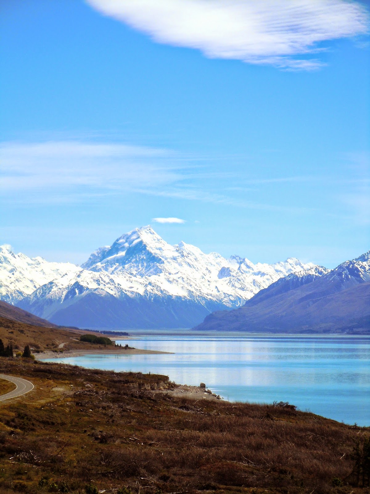
After our ride and lunch, time started chasing us. We both had to work early in the morning, but had no desire to leave. It was arguably the nicest day we'd had yet (ok, every single one was perfect) and we felt no rush. We drove in a leisurely way down the coast towards Greymouth, where we would have to turn inland. We stopped several times, and on one stop I snapped this:
Camera phone or not, is this not the most beautiful place you've ever seen?! I know!!!
Now I just need to be philosophical for a moment here.
There are hard things about living abroad. Missing family and friends goes without saying. Missing places, food, certain ways of life. Leaning new cultures, etc. There's challenges, but a lot of it is why you move.
But the hardest thing for me about living in New Zealand is this: the longer I live here, the more I realize that I can never see it all. And this is a place you want to see all of. Or at least I do. I will never tire of the ferns, the rivers, the glaciers. I can't see one too many dramatic mountains, hear too many native birds, or tire of the smell of the beech forest.
Every time we travel, whether it be an hour-long drive to Akaroa, or across the island, we see signs. They're usually yellow, and always point down a dirt road. Waterfall. Gorge. River. Outlook. Scenic Route. (This one always kills me, because every road is the scenic route.) We're always enroute to somewhere, and though we can occasionally stop and explore, we often can't, and we certainly couldn't see them all.
We've been in New Zealand for two years and I've realized this: I'm never going to get enough. I don't know how long we're going to stay here, and I get excited about all kinds of other opportunities around the world. But be it 2 more months or 2 more years, or a lifetime... It would be impossible to see it all. It's something I have to learn to be okay with, as a part of my heart now belongs to New Zealand's little side roads.
This road popped up on our left just a few moments before we needed to turn inland and end our journey. We were chasing sun and pressed for time and it was gated off. But this time we stopped anyways, and walked, and threw rocks in the river, and marveled at the cliffs, and chased dragon flies and enjoyed a moment of unplanned happiness.
And then we happily drove home.